The whole parcel is FEMA floodway and in MSHCP Criteria Cells — both covered below.
eXp Commercial · DRE #02086093
Request the OM↗Constraints & approvals↓Aerials from the prior marketing package, capture dates to be confirmed · parcel line on USDA NAIP 2022 · slow push-in from a still, not video footage
One parcel. Light Industrial. A logistics corridor, with the constraints in plain view.
Seller financing offered, per the seller: 80% carry with 20% down, 25-year amortization and a 10-year balloon; rate to be negotiated.
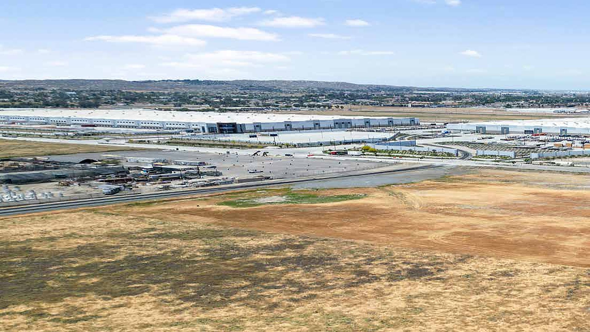
The land, in view.
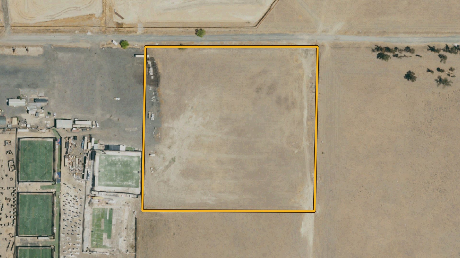
Aerial image from the prior marketing package; capture date and source to be confirmed — conditions may have changed
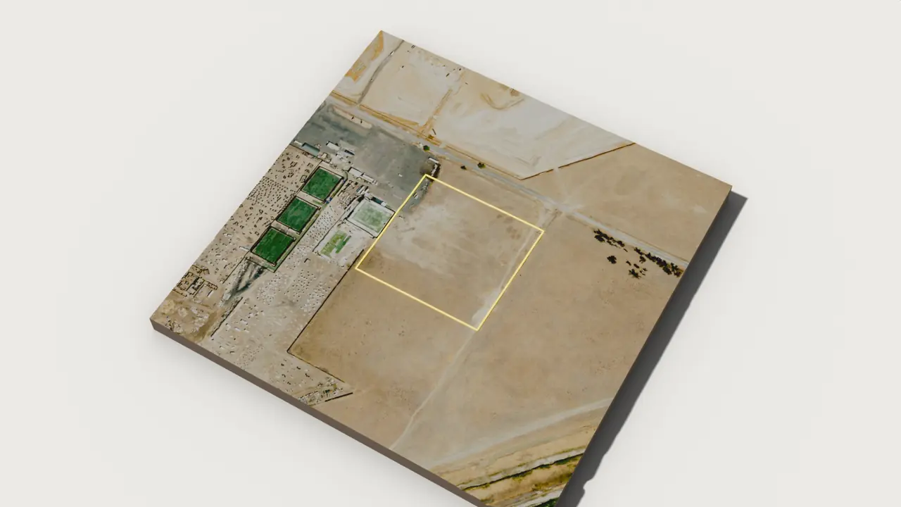
3D exhibit · Blender 5.2
The site, turned in your hand.
One parcel.
±9.40 acres per the offering (8.96 AC in assessor GIS) on the south side of E. Ellis Ave.
Flat ground.
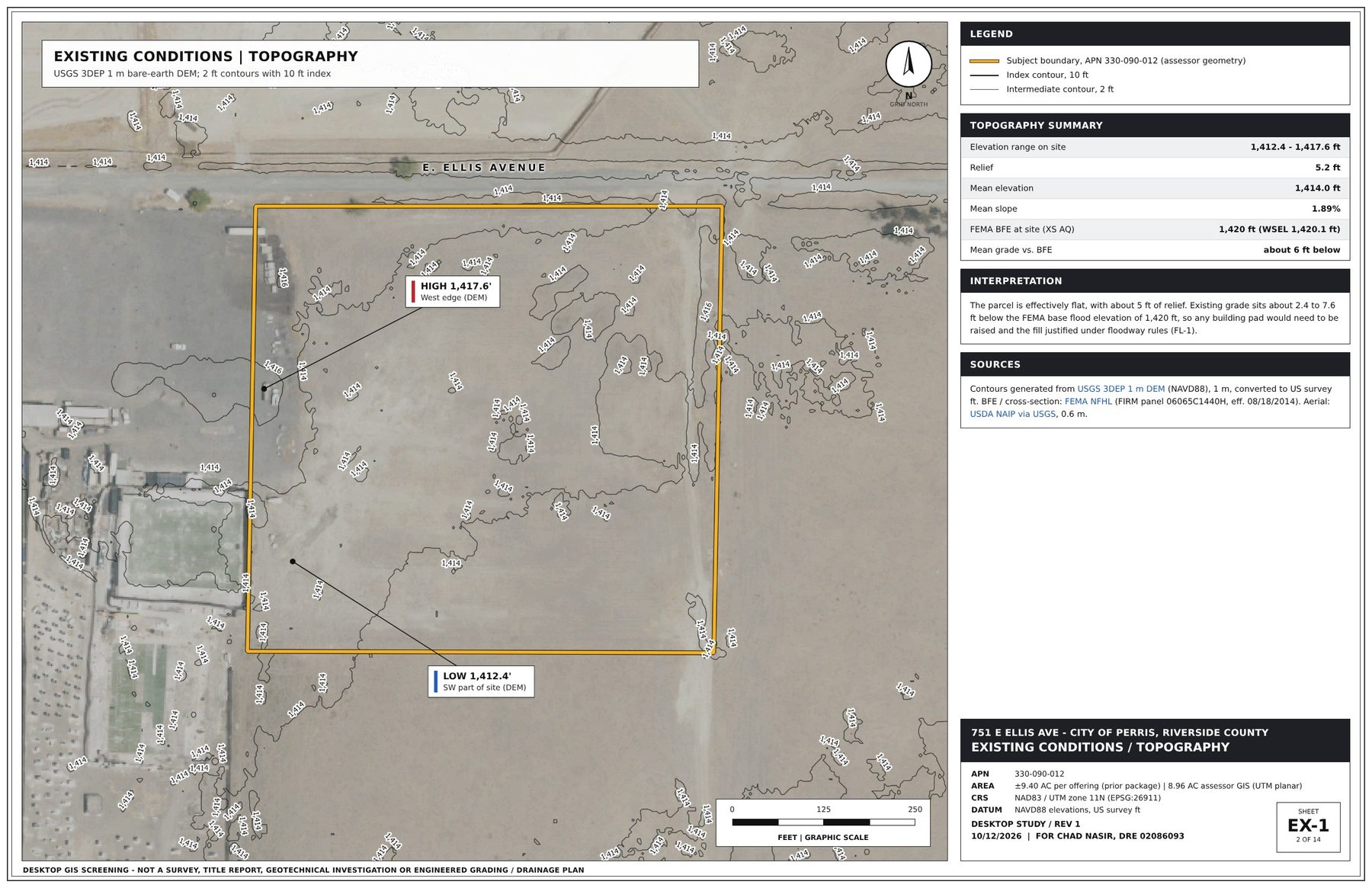
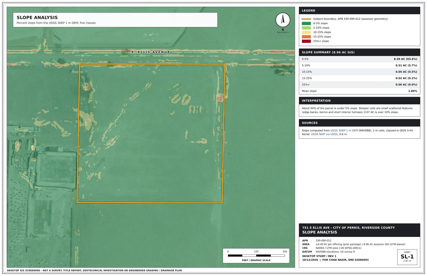
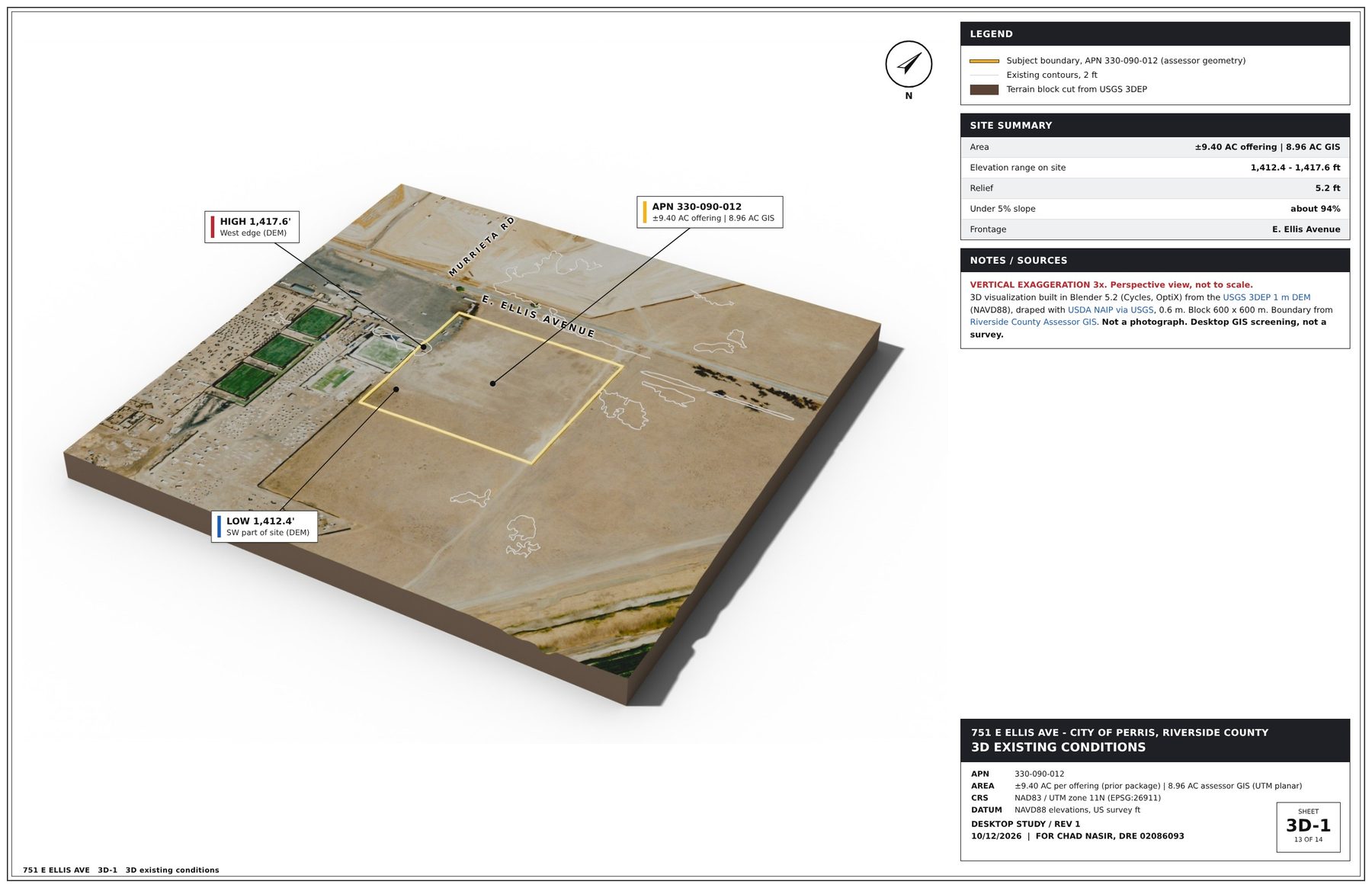
1,412.4 to 1,417.6 ft across the site — 5.2 ft of relief; about 94% is under 5% slope.
Floodway, disclosed.
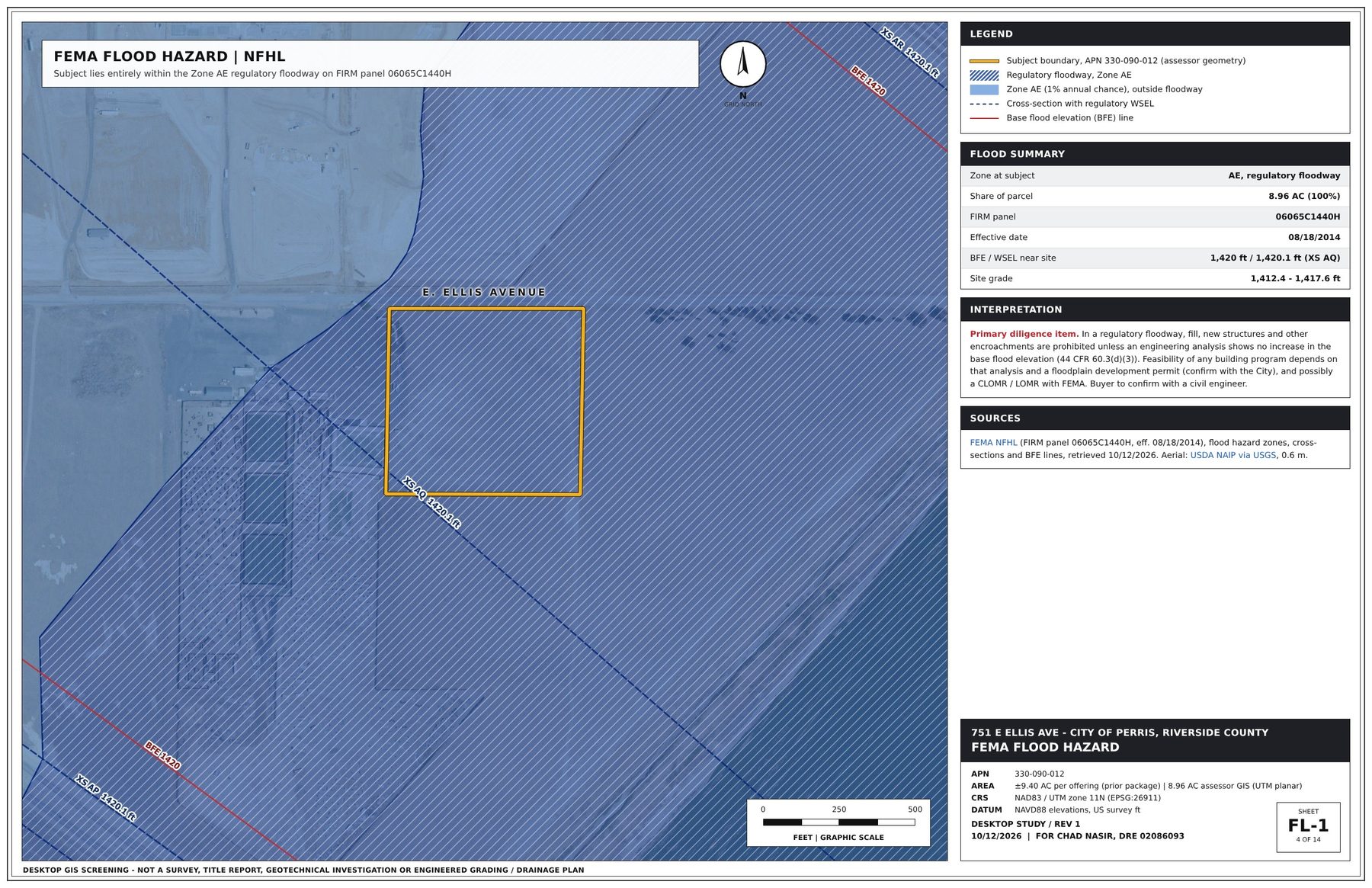
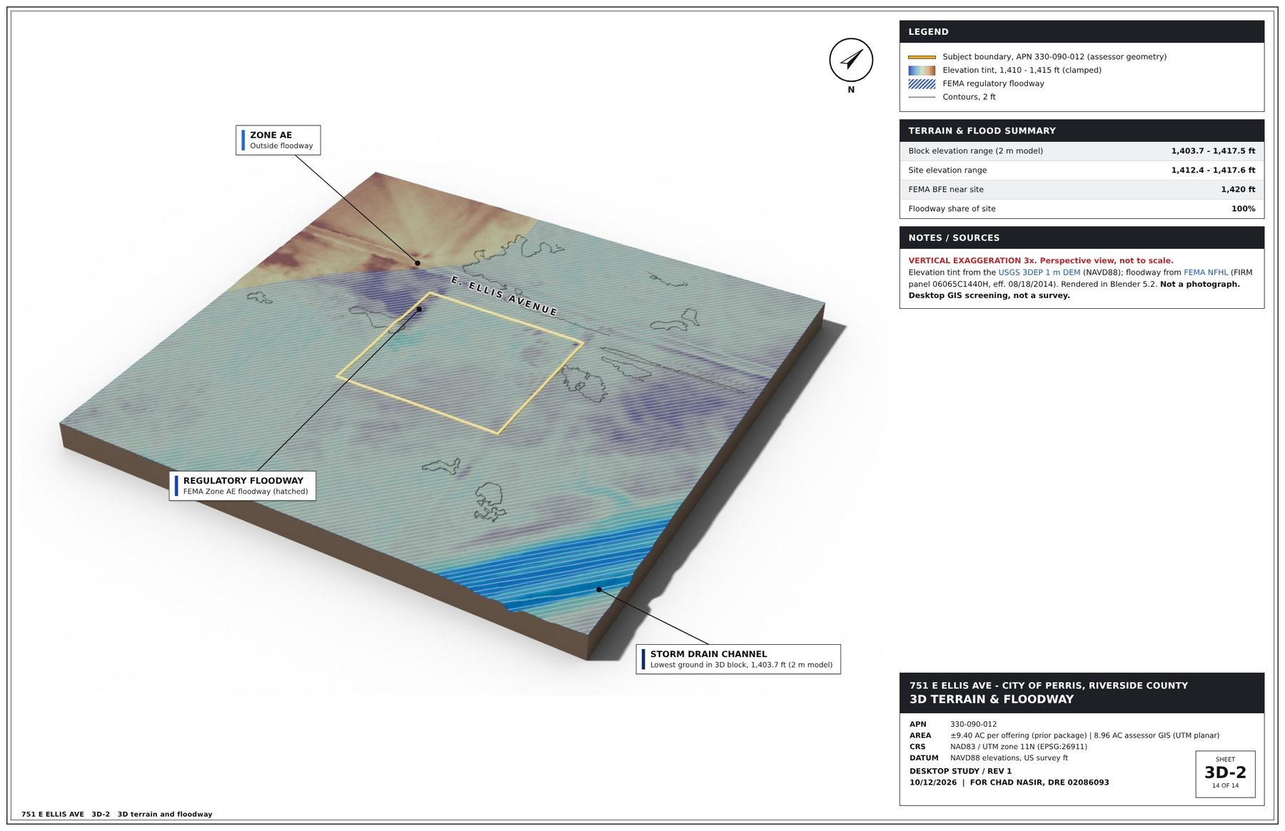
The whole parcel is FEMA Zone AE regulatory floodway; the base flood elevation is 1,420 ft.
Industrial next door.
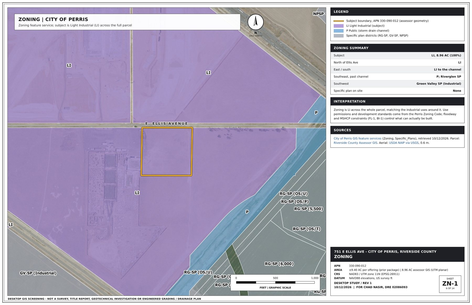
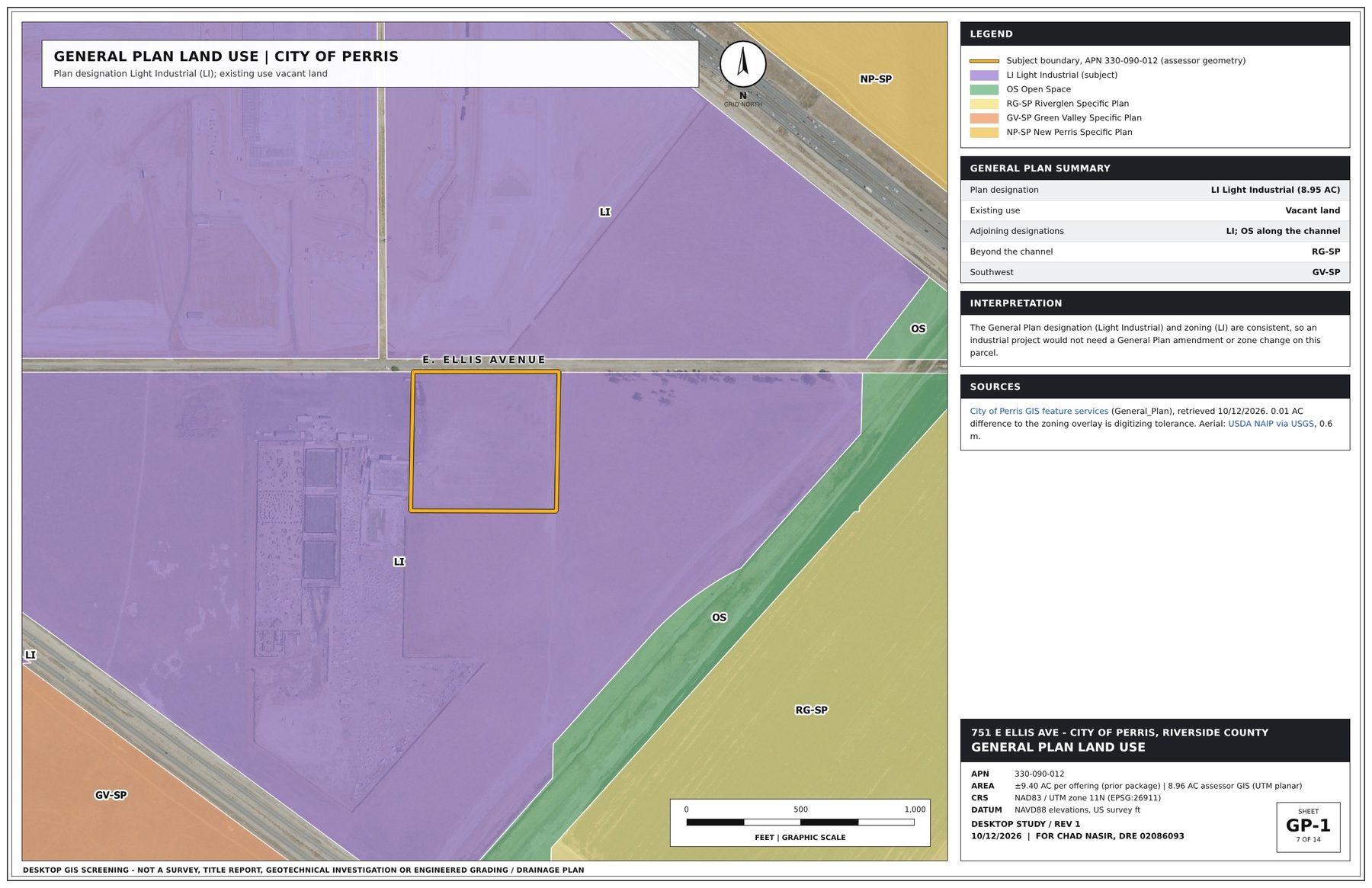
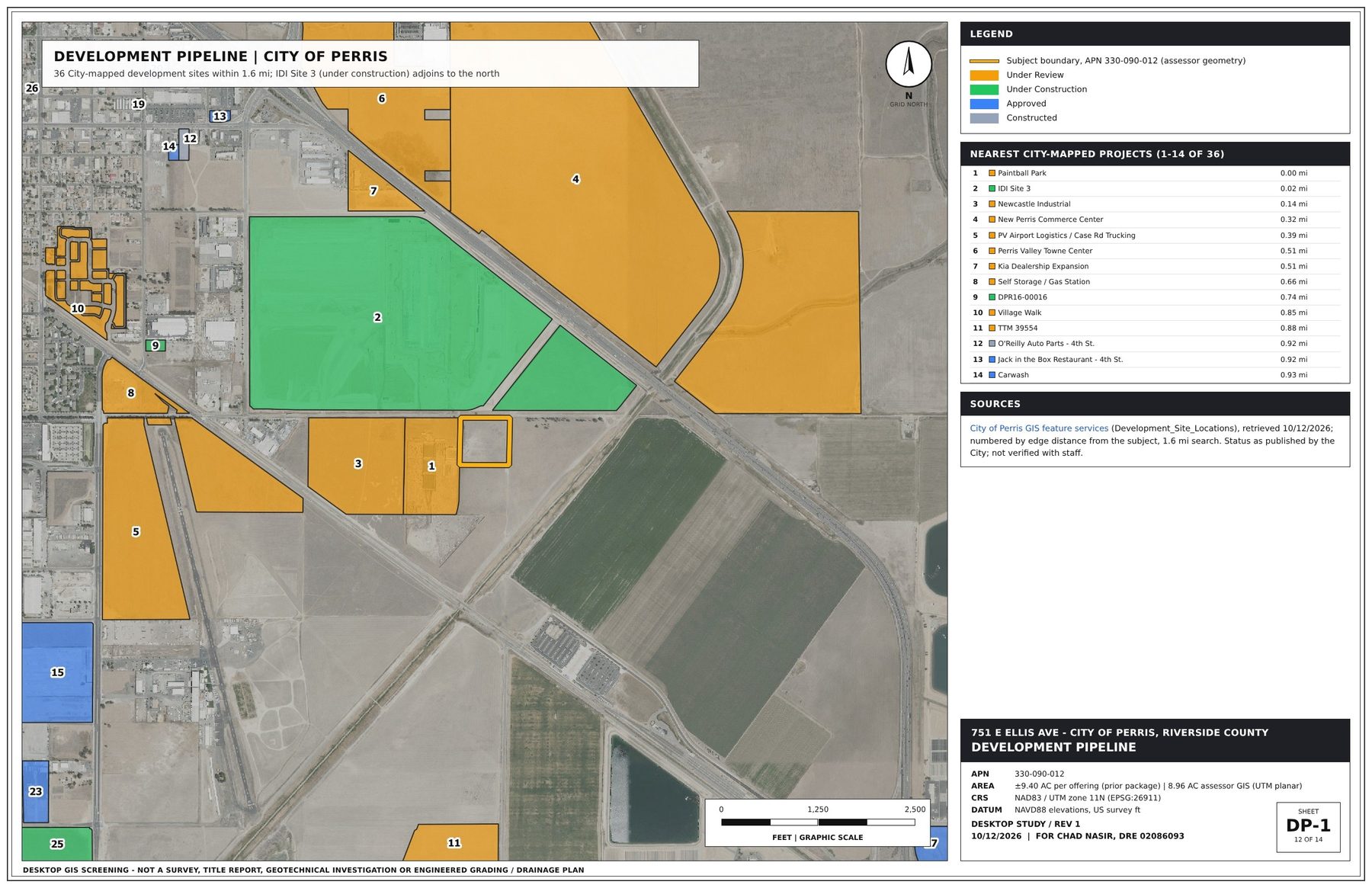
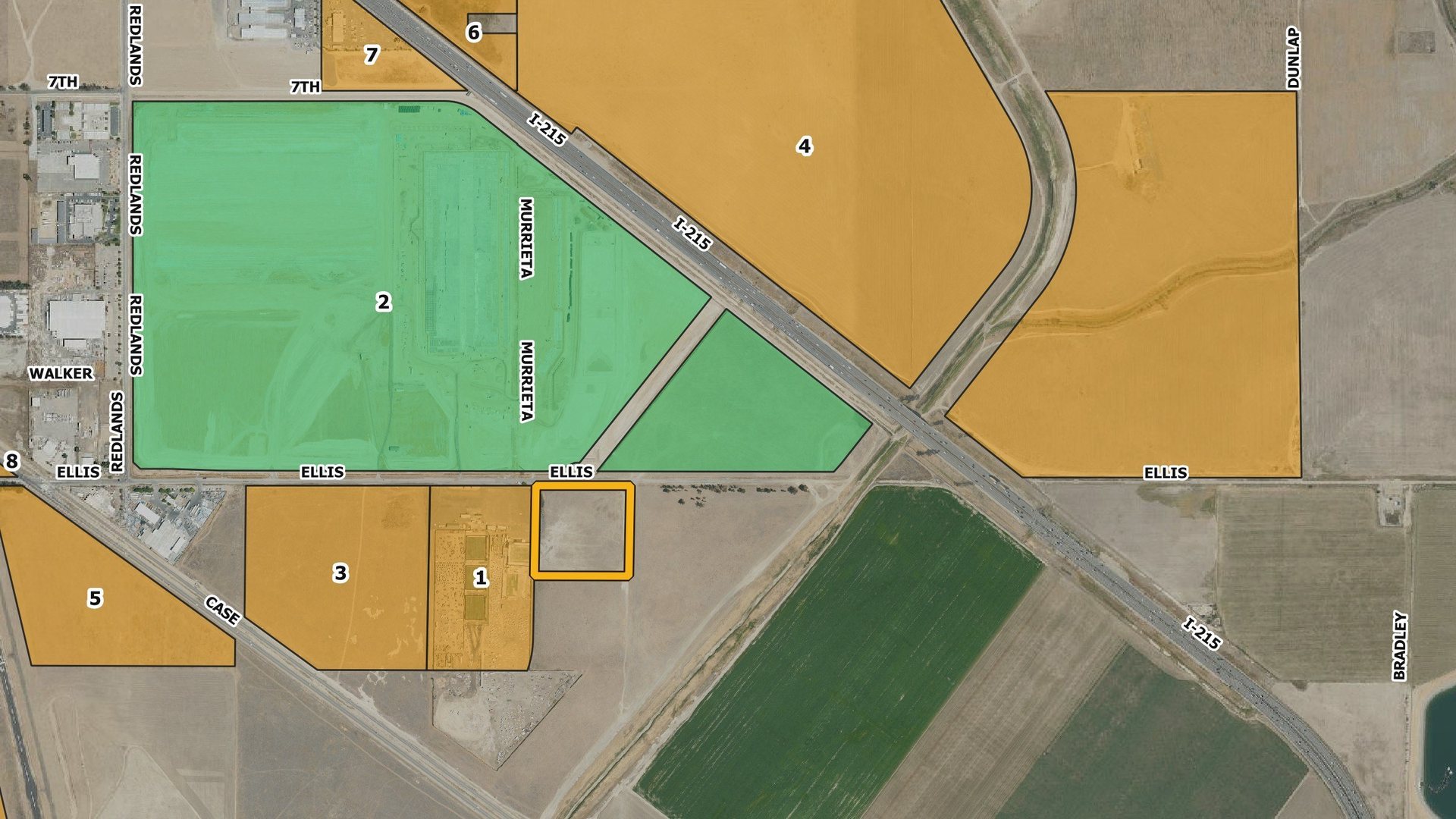
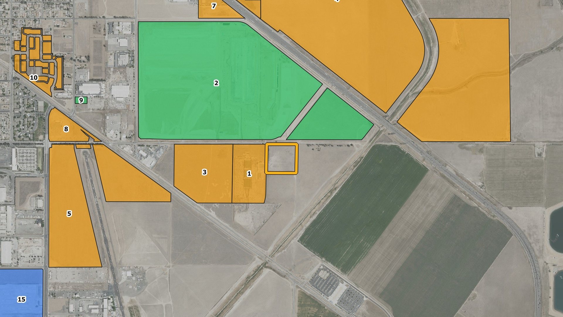
LI zoning. IDI Site 3 is under construction to the north; Newcastle Industrial is under review to the west.
3D visualization from USGS 3DEP 1 m elevation + USDA NAIP imagery · vertical exaggeration 3x · yellow = Riverside County Assessor boundary · not a photograph, not a survey
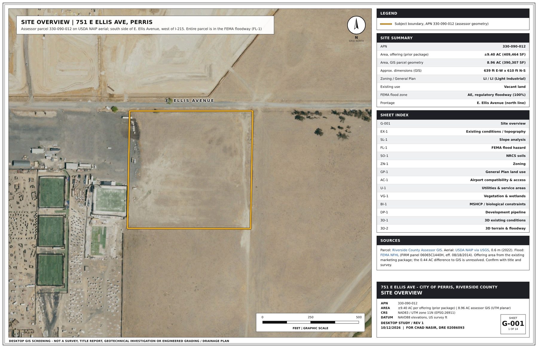
GIS site analysis
Fourteen sheets, one scroll.
Built in QGIS 3.44 and Blender 5.2 from County, City, FEMA, RCA, EMWD, USFWS, USGS 3DEP, USDA NAIP and NRCS SSURGO data. Desktop screening, not a survey.
The ground, up close.
Slow digital push-in on a still aerial image from the prior marketing package — not video footage. Capture date and source to be confirmed.
Offered at $7,750,000
Ownership offers ±9.40 acres of Light Industrial land in the City of Perris, with seller financing available.
| Price | $7,750,000 — $18.93/sf on the offering area; $19.86/sf on the GIS area |
| Seller financing | 80% carry ($6,200,000); 20% down ($1,550,000); 25-year amortization; 10-year balloon; rate to be negotiated |
| Jurisdiction | City of Perris, Riverside County |
| APN | 330-090-012 |
| Site area | ±9.40 acres (409,464 sf) per offering · 8.96 acres per assessor GIS |
| Zoning | LI — Light Industrial |
| General Plan | Light Industrial (plan designation) · existing use: vacant land |
| Flood (FEMA) | Entire parcel in Zone AE regulatory floodway; FIRM panel 06065C1440H, effective Aug. 18, 2014; base flood elevation 1,420 ft |
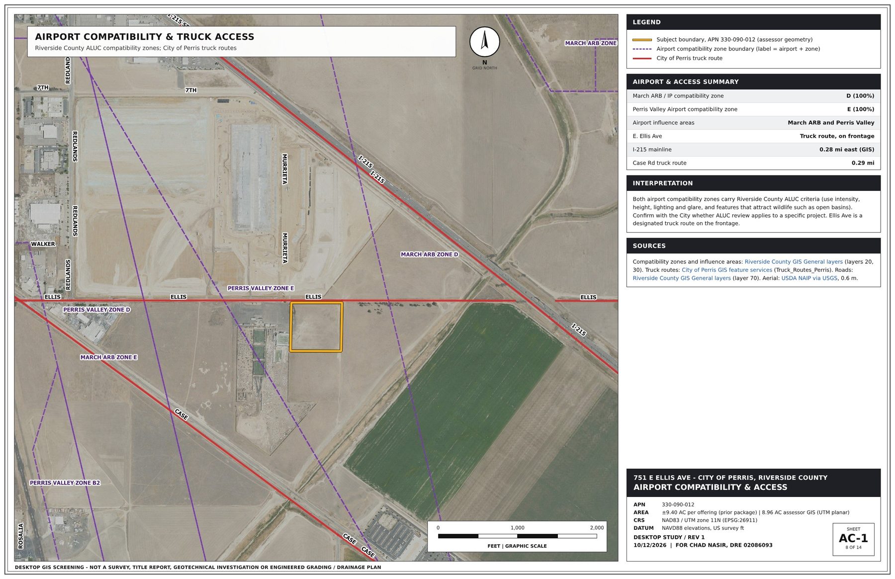
| Frontage | E. Ellis Ave on the north line (City truck route) |
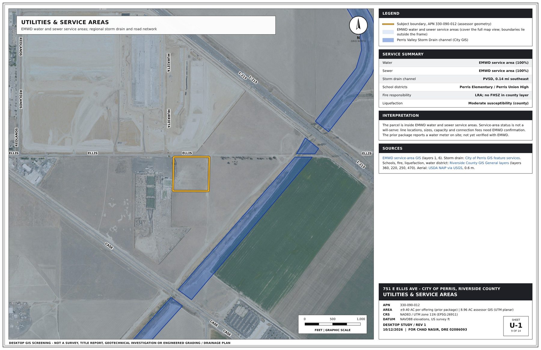
| Water / sewer | Inside EMWD water and sewer service areas (will-serve to be obtained) |
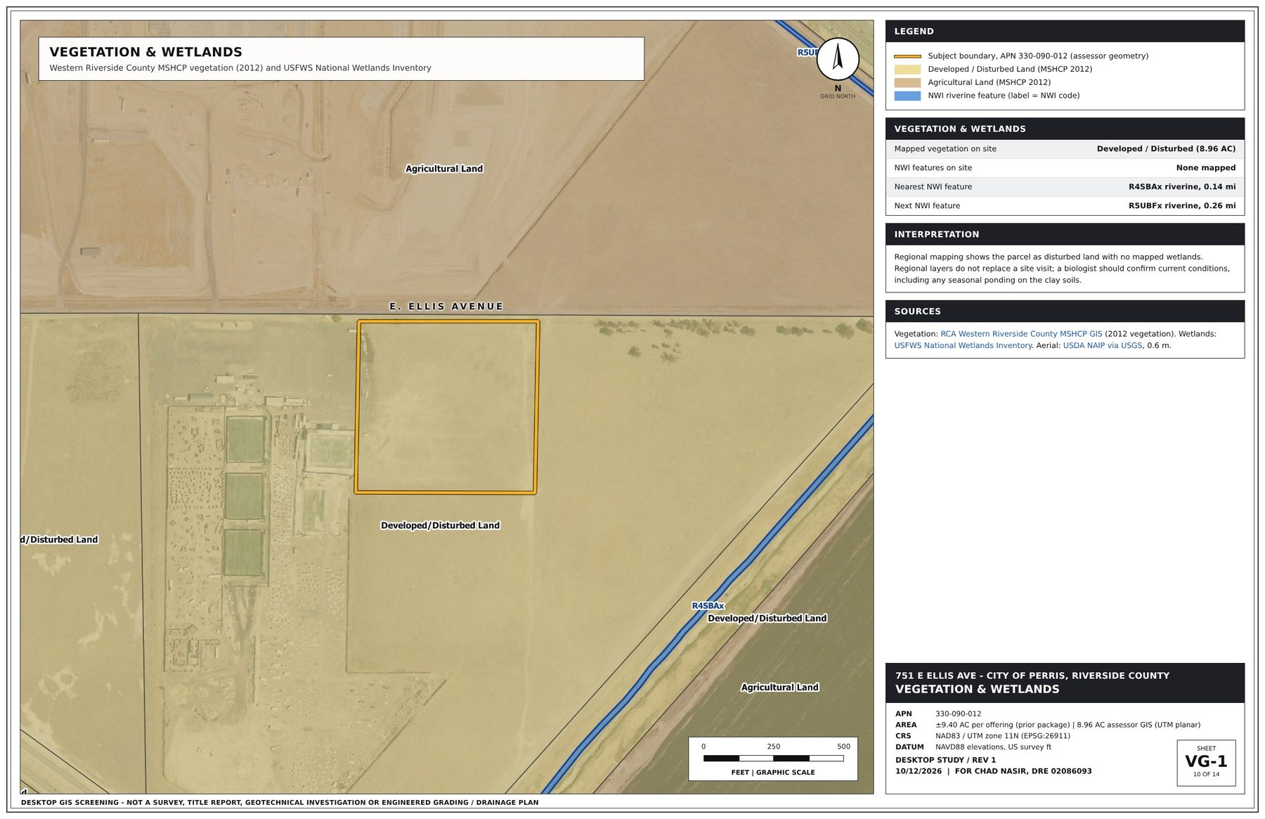
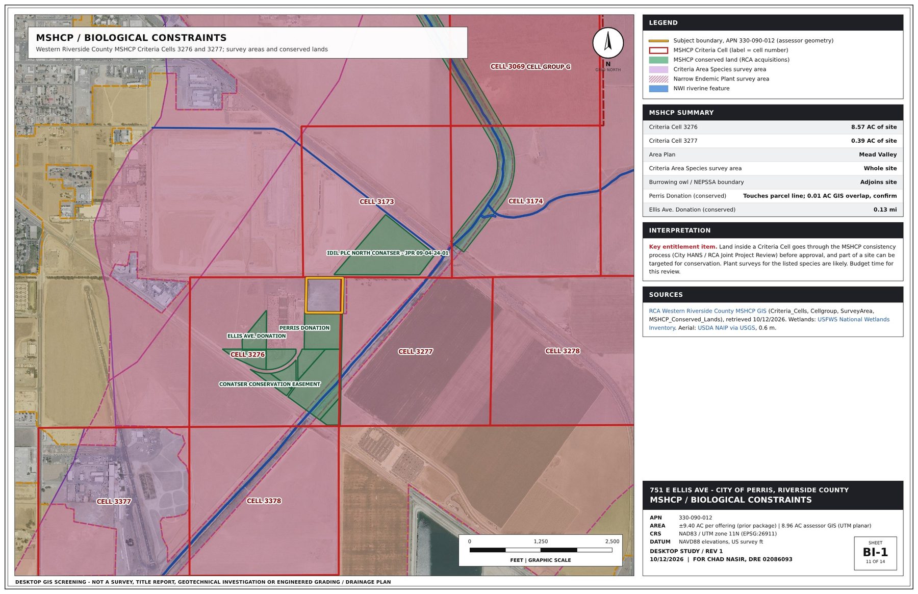
| Biological | Western Riverside MSHCP Criteria Cells 3276 and 3277; whole site in a Criteria Area Species survey area |
| Schools | Perris Elementary / Perris Union High School District |
On E. Ellis Avenue, west of I-215
- I-215 mainline about 0.3 mi east
- Case Rd truck route about 0.3 mi southwest
- Site centroid approx. 33.7712 N, 117.2072 W
Straight-line distances, not drive distances (Riverside County and City of Perris GIS).
- E. Ellis Ave along the north line, a designated City truck route
- About 639 ft of north line in the GIS geometry
- Road improvements, right-of-way and legal access to be verified by buyer
- North (across Ellis Ave): IDI Site 3 — three industrial buildings, 2,797,522 sf, listed by the City as under construction
- West: paintball park (City lists a CUP review)
- Further west: Newcastle Industrial — 643,419 sf, under review
- South and east: open land to the Perris Valley Storm Drain channel
Per City of Perris development site records; statuses as published.
Four reasons to look closely
Industrial zoning in place
LI zoning and an LI General Plan designation across the parcel — industrial use needs no General Plan amendment or zone change (City of Perris GIS).
A logistics neighborhood
About 12.8 million sf of industrial buildings in City records within 1.6 miles, including IDI Site 3 directly across Ellis Ave.
Seller financing
$1,550,000 down with an 80% seller carry, 25-year amortization and a 10-year balloon; rate to be negotiated.
Flat ground
5.2 ft of relief across the site on the USGS 1-m elevation model (1,412.4–1,417.6 ft); about 94% of the site is under 5% slope. Not a survey.
A growing Riverside County city
U.S. Census Bureau QuickFacts, Perris city (V2025 population; income, household, labor force and housing 2020–2024).
Industrial zoning, two constraints to resolve
Industrial use fits the LI zoning and General Plan. What decides a project here is the FEMA regulatory floodway, which covers the whole parcel, and the parcel's location in MSHCP Criteria Cells 3276 and 3277. In a floodway, fill and new structures need an engineering analysis showing no increase in the base flood elevation (44 CFR 60.3(d)(3)). Criteria Cell land goes through the MSHCP consistency review, which can require conservation on part of a site.
- Pre-application meeting with City of Perris Planning
- Floodway no-rise analysis and floodplain development permit (confirm with the City; CLOMR / LOMR with FEMA if needed)
- MSHCP consistency: HANS / RCA Joint Project Review; habitat assessment and plant surveys
- Development Plan Review; CUP for warehouses over 50,000 sf, truck yards or outdoor storage
- Airport land use consistency may apply (March ARB Zone D; Perris Valley Zone E)
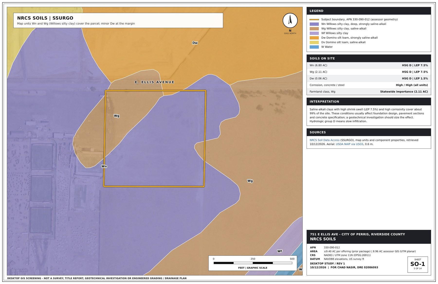
- Geotechnical study for expansive, corrosive clay soils
- CEQA review (document type to be determined)
| Basis | Land sf | 50% coverage | 0.75 FAR |
|---|---|---|---|
| Offering ±9.40 ac | 409,464 | 204,732 | 307,098 |
| Assessor GIS 8.96 ac | 390,307 | 195,154 | 292,730 |
Arithmetic only, before floodway, MSHCP, setbacks, parking, truck courts and storm water. LI standards per Perris Municipal Code §19.44.030 as published online (0.75 FAR, 50% coverage, 50 ft height); verify against the adopted code. Not a site plan, entitlement or estimate of value.
Planned I-215 / Ellis Ave overcrossing: the City's May 2025 EIR notice describes extending Ellis Ave east over I-215 to San Jacinto Ave, with construction anticipated to begin in 2031. EIR in preparation and not approved as of that notice; current status to be confirmed.
Industrial projects nearby
Industrial projects in the City of Perris development site records within 1.6 miles: about 6.1 million sf under construction, 1.1 million sf approved and 5.5 million sf under review. Statuses are as published by the City and not confirmed with staff (the Newcastle record lists "under review" with an approval date of 11/6/2024). Distances are straight-line, edge to edge.
| Project | Industrial sf | Status | Distance |
|---|---|---|---|
| IDI Site 3 | 2,797,522 sf | Under construction | 0.02 mi |
| Newcastle Industrial | 643,419 sf | Under review | 0.14 mi |
| New Perris Commerce Center | 3,681,020 sf | Under review | 0.32 mi |
| Perris Valley Airport Logistics | 867,070 sf | Under review | 0.39 mi |
| DPR16-00016 | 6,100 sf | Under construction | 0.74 mi |
| IDI Site 1 Prologis | 754,139 sf | Approved | 0.98 mi |
| Waypoint Industrial | 352,177 sf | Under review | 1.17 mi |
| CSLM Construction | 6,115 sf | Approved | 1.24 mi |
| IDI Site 2 | 3,345,217 sf | Under construction | 1.27 mi |
| Blue Marquise | 350,000 sf | Approved | 1.33 mi |
City of Perris Development_Site_Locations layer, retrieved Oct. 12, 2026; square footage as stated in each project description (current figure where a modification is listed). Excludes projects that do not state warehouse square footage.
Flat, and below the flood elevation
The 1-m USGS 3DEP elevation model ranges from 1,412.4 ft to 1,417.6 ft across the parcel — 5.2 ft of relief — and about 94% of the site is under 5% slope. The FEMA base flood elevation at the site is 1,420 ft, so existing grade sits about 2.4 to 7.6 ft below it. Not a topographic survey; buyers should commission their own.
USGS 3DEP 1-m DEM, contours and slope derived in QGIS 3.44; FEMA NFHL cross-section AQ.
GIS site analysis sheets
Built in QGIS 3.44 and Blender 5.2 from official County, City, EMWD, FEMA, RCA, USFWS, USGS and NRCS GIS data — not a survey, title report or entitlement determination. Select a card to enlarge.
Source links
Request the Offering Memorandum
Interested buyers may request the OM and submit offers through the listing broker.
Vice President of Land & Acquisition
eXp Commercial of California, Inc.
DRE #02086093
(949) 358-0056
sales@realestateca.org
500 Technology Dr Suite 307, Irvine, CA 92618